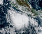
A rapidly intensifying tropical storm has exploded into a powerful category 5 hurricane near Mexico’s southwest coast, with winds now exceeding 165 mph. Positioned about 215 miles south of Zihuatanejo, the storm—fueled by unusually strong El Niño conditions in the Pacific—has grown from a tropical depression to a major hurricane in less than a day. While its current path suggests it may not make direct landfall, its strength and proximity raise concerns for coastal areas. Forecasters are monitoring its trajectory as it continues to strengthen.
Polo, with sustained winds of 165mph, is churning 215 miles south of Zihuatanejo but is unlikely to directly hit MexicoA tropical storm off the south-west coast of Mexico has intensified into a category 5 monster in fewer than 24 hours, fueled by stronger than usual El Niño weather patterns in the Pacific Ocean.Hurricane Polo was sending out maximum sustained winds of 165mph (266km/h) on Tuesday as its center churned about 215 miles (346km) south of the coastal city of Zihuatanejo, in Guerrero state. Continue reading...


