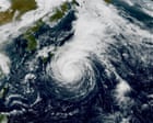
A strengthening storm system is set to impact the Izu Islands as Tropical Storm Dujuan regains typhoon intensity, bringing sustained winds nearing 80 mph and gusts close to 100 mph. Though Japan’s mainland has so far avoided a direct strike, the storm’s path has prompted evacuation warnings and widespread alerts for flooding, landslides, and dangerous coastal conditions. Meanwhile, the Atlantic hurricane season remains unusually quiet, contrasting with the Pacific’s active system. Residents in the storm’s projected path face heightened risks from heavy rainfall and storm surges.
Storm system expected to hit Izu Islands as it strengthens. Meanwhile, Atlantic hurricane season is unusually quietTropical Storm Dujuan is skirting the coast of Japan and despite avoiding a direct landfall, is still expected to leave its mark. Dujuan briefly reached typhoon status on Friday before weakening to a tropical storm again on Sunday morning. But it is expected to restrengthen back to a typhoon by Tuesday morning. Sustained winds could reach 80mph (129km/h), with gusts approaching 100mph.Although mainland Japan has avoided a direct hit, Dujuan’s track takes it across the Izu Islands, where evacuation warnings are in place. Heavy rain, flooding and landslide alerts are widespread, with high waves adding another threat to exposed coastal areas and islands. Continue reading...


